 |
|||
| |||
|
|||||||


| Underground Sewers, Culverts, Caves, Mines & Air raid shelters etc. |
 |
|
|
Thread Tools | Display Modes |
  Culverts - do maps exist? Culverts - do maps exist? |
|
(#1)

|
||||
|
||||
|
I have really enjoyed browsing the pages especially Tew Brook and various Halton pictures. I remember as a young lad (I'm in my forties now) going down a culvert near Belle Vale Police Station and traveling along it until we came out in a farmers field about half a mile westerly - never went easterly, too dark, scared and young! I now live a couple of miles away in Halewood which has lots of streams, brooks - are any of them mapped? Just out of interest I'd like to know their source. Thanks in advance ... 
|
||||

| |
|
(#2)
|
||||
|
||||
|
I'm gessing, but i would say maps should exsist. is it not something that would be checked when you buy a house? there is a short culvert near my house, and the direction it heads in was something we had to have looked into before we could get a mortgage.
|
||||

| |
|
(#3)
|
||||
|
||||
|
Ive been intouch with united utilities/northwest water about underground watercourses a few years ago and they said there is an office in wigan that you can apply to or visit to get a map of the area your looking into. Maybe worth trying them you never know.
|
||||

| |
|
(#4)
|
||||
|
||||
|
you can look at the public water records at the local libary (lists sewers and that, should probbably list culverts too)
easy to find em if you just follow a river on google earth though!
|
||||

| |
|
(#5)
|
||||
|
||||
|
oh and the book 'underground liverpool' has a map of all the watercourses and culverts in liverpool, ill scan in the page if you want (although I dont think it stretches to halewood, cant remember!)
|
||||
| |
|
(#6)
|
||||
|
||||
|
and if this helps at all:
http://wtp2.appspot.com/wheresthepath.htm you can flip between the maps and take a rough guess at the routes, and in some circumstances jump between a ud o/s map and a 1940's o/s map 
Send three and fourpence we're going to a dance
|
||||

| |
|
(#7)
|
||||
|
||||
|
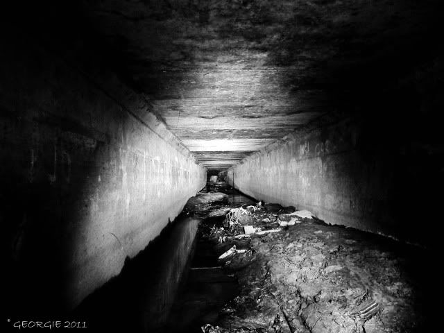
welcome in m8 ive done a few culverts lately but theyve been all in liverpool...the most recent we done was one at netherley which was quite large and mostly manhloed.....there was a date stamped on the wall in one of them 1968...and some graff from 1971 which was cool
there are maps m8 that have these culverts on thats how i found the jordan river and as asour mentioned it was in the underground liverpool book i havent come across any maps for up by yours although i have one which mentions halewood brook best way to find out where they go tbh is jump in one and follow it, altough the ones ive been in lately have been back breakers
|
||||
| |
|
(#8)
|
||||
|
||||
|
heres a look at the netherley one which runs parallel to halewood brook then they both meet ditton brook
|
||||
| |
|
(#9)
|
||||
|
||||
|
A lot of local councils have electronic mapping systems which do include underground watercourses. Lancashire council has MARIO, Warrington Council has a similar one but the name escapes me - but that's only available internally, You might be able to get it in libraries though.
|
||||

|
| Bookmarks |


«
Previous Thread
|
Next Thread
»
| Currently Active Users Viewing This Thread: 1 (0 members and 1 guests) | |
 Linear Mode

|
|
Powered by vBulletin® Version 3.8.6
Copyright ©2000 - 2024, Jelsoft Enterprises Ltd.
vBulletin Skin developed by: vBStyles.com
Copyright ©2000 - 2024, Jelsoft Enterprises Ltd.
vBulletin Skin developed by: vBStyles.com
© 2008-2015. Photographs and text are copyright and the property of the poster unless otherwise stated, and should not be used without express written permission.
Any opinions stated by users of this forum are NOT those of the site owners, each poster takes FULL responsibility for their own posts.
Any opinions stated by users of this forum are NOT those of the site owners, each poster takes FULL responsibility for their own posts.